 Whilst the likes of Amazon’s plans for drone based deliveries have received a large dollop of popular attention, arguably the most interesting application of the technology has been in monitoring landscapes.
For instance, farmers are using drones to keep tabs on everything from livestock to soil quality, whilst Project Premonition is using it to keep tabs on disease. Indonesia is using them to monitor traffic flows, and a Californian project is even using them to monitor progress on a building site.
Monitoring ice levels
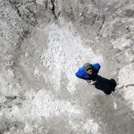
A project underway in the Peruvian Andes is hoping to use drones at 5,000 meters to monitor and map the glaciers of the Cordillera Blanca mountain range.
“In this area, glacier melt provides up to 50 percent of the water during the dry season, and people use it for farms, hydroelectricity and to drink,” the team say. “We know the glaciers are disappearing, so there will be less water available for the dry season in the future. But what my colleagues and I have found is that the groundwater system is storing some of the glacier melt as well as precipitation. There will still be a significant drop in water supply eventually, but there may be some potential for the groundwater to buffer it.”
The richness of data extracted from the project would have been incredibly difficult to obtain without the specially designed high-altitude drones that the team built for the project. The devices were fitted with time-lapse thermal cameras to capture footage of the glaciers.
“UAVs offer some of the best technology available today for gathering data on a scale to inform local water management decisions,” the team say.
By using drones, the team are able to overcome traditional hurdles such as difficult terrain, cloud cover and thin air.
The glaciers of the Cordillera Blanca are crucially important for our understanding of the climate, and in particular the water resource contained in the glacier.
A fresh approach
Cloud cover blocks satellite images of the Cordillera Blanca for all but a few weeks each year, whilst the terrain is so challenging as to make regular ice measurements difficult to take by hand.
The traditional alternative to these would involve flying an aircraft over the glaciers, which is both expensive and perilous.
The drones, by contrast, can record images to a resolution of 10 centimeters for just a few thousand dollars. This represents both an improvement in performance for a fraction of the cost.
The drones provide the researchers with hundreds of images that enable a 3D picture to be developed in a similar way as the human eye.
By using thermal, infrared cameras, the team are capable of monitoring the temperature of the glacier over time and create a dataset that is considerably richer than is traditionally possible.
“In traditional glaciology fieldwork, researchers would just record data at one or two spot locations, and extrapolate this data across a whole, huge glacier. With the new infrared camera technology, we can now instantaneously measure the temperature of the glacier everywhere, repeatedly, which is giving us new insights,” the team say.
“These new technologies, combined with the UAV mapping, are allowing us to observe glaciers in ways that we would never have thought possible even a couple of years ago. It is really an exciting time to be involved in this research,” they continue.
It’s a great example of just how useful drone technology can be, even when receiving a fraction of the attention Amazon’s project has received.
I love this. Such a great utilisation of the technology.