 There has been impressive progress in recent years in automated means of exploring the unexplored, whether it’s underwater drones or space going robots.
ROVINA is another such project by the European Union. They have developed a new robotic system that the team believe are pushing the boundaries of robotics.
As we can perhaps imagine, exploring uncharted territory not only involves arduous terrain, but also poses unique challenges to scanning technologies, such as poor visibility. Such remote areas also present a communication challenge, and make human supervision very difficult.
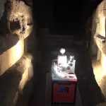
To overcome them, the team called upon a wide range of specialisms, from robotics to 3D reconstruction, object detection to semantic analysis. The end product was tested out by exploring the catacombs of Rome and Naples.
Robot explorers
These prototypes allowed the team to fine-tune the interfaces used by the robot to engage with its surroundings. There was also a lot of work done to make the user interface as friendly as possible, as the device is likely to be controlled by a range of people, from historians and archaeologists, to engineers and maybe even virtual tourists.
The development of this prototype also highlighted important progress with regards to the machines reliability and autonomy. The machine was capable of performing smarter navigation and processing of sensory data. It’s initial use will be in cultural preservation projects.
“With the ability of quickly acquiring digital models over time using the ROVINA system, combined with the tools for the analysis of temporal change in sites, it is possible to monitor levels of decay,” the team say.
The team are confident that as the ROVINA robot reduces both the tine and expense of doing this work, the number of investigations the team can undertake can increase without stretching their budget any more. This will be especially so if and when the robot becomes capable of autonomous, or even semi-autonomous, operation.
Should this use case prove successful, they believe that the work that has gone into ROVINA should be of value to other projects that are looking at autonomous robotics. To support this knowledge transfer, the development components for the project have been made available under a dual license model, with open source software published on the project’s website.
“ROVINA’s main target was geometric modelling firstly, with semantics only to some degree. We believe that the semantic aspect offers future potential and must be exploited. Secondly we need to simplify the robotic use and to target the automation of geodetic high-precision scanning, currently labour-intensive and so an expensive task,” the team say.