 Last year researchers from the University of Alberta proposed using AI to predict forest fires. The software used artificial neural networks to sift through the data and then predict where extreme weather events are likely to create the kind of conditions conducive to a forest fire breaking out. The system is trained on historical data, before then making probabilistic predictions, which are in turn approved (or not) by expert researchers. If the predictions are not approved, the system modifies its approach and tries again.
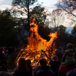
Researchers from KTH Royal Institute of Technology in Sweden have developed a similar system that they believe can help authorities predict the onset of forest fires in the Nordic nation. It’s a problem that has blighted the country this year, with many communities warned not to light the traditional bonfire that marks the final night of April.
Big data
The system pulls in satellite data and utilizes machine learning to then monitor for natural disasters in near real-time so that the Swedish Civil Contingencies Agency (MSB) and fire fighters can quickly assess any fires currently in progress. The method is able to ‘see’ through smoke, thus providing a clear view of the fire and the damage it has caused.
“With really good resolution – down to 10 meters – we can get updates of the status every two to three days. This is not as frequent as we wish, which can be remedied by lower resolution with data from VIIRS (375 meters) or MODIS (1,000 meters),” the researchers explain.
At the moment the team are relying primarily on free data, which limits the effectiveness of the tool quite considerably. They believe that if MSB was a part of various international organizations, such as the International Charter Space, then they would have access to much higher quality data to train the system with.
Until then however, the system will be boosted by the launch of the Canadian RADARSAT constellations in 2019, and the radar CubeSat constellations by ICEYE and Capella Space, with radar images from both systems available on a daily basis to help provide real-time forest fire monitoring across Sweden.