 Despite the tremendous growth in pilot support tools, pilot error has remained the most common cause of air crashes over the last 50 years or so. The stats reveal that pilot error has consistently contributed to around 55% of all air accidents in that time.
With most drones having a human pilot, it seems inevitable that similar figures will unfold as drone usage increases, despite various attempts to make drone usage safer.
Self navigating drones
One option could be to take navigation out of the hands of humans altogether. A team of researchers from the Swiss Federal Institute of Technology are working on drones that can operate independently.
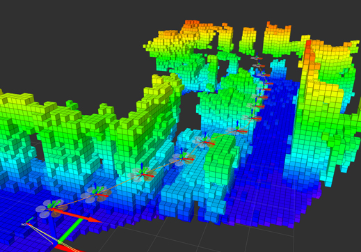
They have prototyped a drone that can construct it’s own 3D map of an unfamiliar environment with minimal input from a human operator. It can then use this map to plot its own route around the environment.
“This is the first time we can show full mapping, relocalization—finding the drone on the map—and planning on board,” the researchers say.
The technology would require one flight to produce the map, after which the drone can then operate autonomously. It is capable of using the map to navigate the most efficient route around the location.
The map itself was created using a stereo camera and a number of sensors to track things like velocity, gravitational forces and orientation.
The drone was put through its paces at a disused industrial site, with the location chosen for the challenging nature of the terrain.
The path to automation
The team have brought together mapping and sensing techniques that were already on the market into what is believed to be the first instance of an autonomous drone.
“This brings the technology closer to real-world application in inspection and surveillance tasks,” the team says. A paper on the new system was presented at the International Conference on Intelligent Robots and Systems last month.
Suffice to say, the system still needs to be honed before it can find its way into commercial use. The extra weight of the equipment reduces the fly time of the drone to just seven minutes, but the team are confident that this can be improved to achieve times of around 20 minutes quite comfortably.
The next step is to configure the system so that it can also detect moving as well as static objects, thus rendering it capable of avoiding collisions with items (such as birds, equipment or humans) that don’t appear on its map.
It’s a fascinating glimpse into the potential for automated flying. Check out the video below for more information.
Wow, incredible. What with this and the self learning stuff yesterday, where is the role for us?