 Deforestation is one of the more important, yet often under-appreciated, of environmental issues, both for the climate change benefits trees offer but also the huge biodiversity benefits to species around the world.
I wrote earlier this year about an attempt to use big data and AI to improve our understanding of deforestation. Orbital Insight take satellite images of forestation around the world and use smart AI algorithms to identify threatened areas before potential deforestation can take place.
Using the crowd
An alternative approach is used by the Geo-Wiki team, who have turned to trained citizen scientists to hopefully ensure deforestation maps are more accurate and useful.
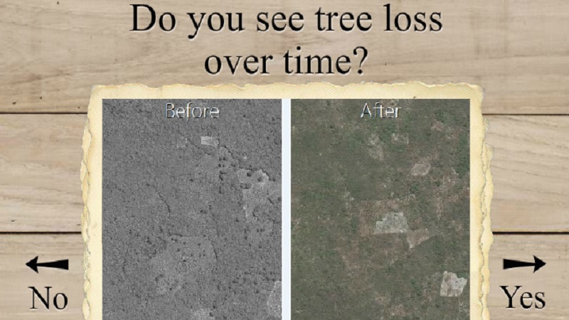
The Picture Piles app has gone down a similar path, taking their inspiration from topical dating site Tinder. Whereas on the dating app you swipe right if you like the person on your screen (and left if you don’t), with Picture Piles you’re using the swipe to signify forest cover changes.
The app, created by the IIASA, focuses on forestation in Tanzania and provides before and after shots of areas of land. Users swipe to signify whether trees have been cut down, with the aim being to provide researchers with a richer insight into the latest trends.
“It’s easy to look at an aerial photo or high resolution image and say, are there trees there or not?” said IIASA researcher Steffen Fritz.
“But to build a map you need millions of data points—and to see change over time you need to repeat the exercise for multiple years of data.”
It’s hoped that by recruiting the crowd, it will make the task of sifting through the 5 million images in the dataset that much easier. In the few weeks since the app launched, there have already been over 100,000 photos processed, so progress has been good thus far.
Participants are incentivized by leader boards that rank them according to the number of photos processed.
The inspiration for the project was Cropland Capture, which was a similar app launched back in 2011 to help map agricultural coverage around the world. It was incredibly successful, with several thousand players mapping an area the size of India in a matter of months.
The team are confident that the approach is such that other problems can also be assessed, whether that’s water availability or disaster damage.