 I’ve written previously about using drones to track the movement of sharks in Australia and keep surfers safe. That isn’t the only project using drones for monitoring wildlife however.
For instance, a European project is using drones to try and monitor fish numbers and tackle depletion. The EU Fisheries department suggest that 93% of fish stocks in European waters are overexploited, and the agency is considering the use of drones to help police the waters.
“I have heard of drones being trialed to control fisheries, telling us not only where a boat is located, but whether it has its nets in the water,” they said at a recent meeting in Italy.
Monitoring ecosystems
The agency can perhaps gain inspiration from a project underway in Ecuador that is exploring how animals respond to climate change.
Such observations typically require monitors to be incredibly close to the organisms, with some as close as one centimetre, but that level of detail prevents widespread observation.
The team overcome this issue by using drones, heat sensors, mapping and statistical processing software applications.
The drones can provide data on local temperatures at both a spatial and temporal scales. Such work still lacks a clear methodological framework however in order to process this data.
A monitoring toolbox
The team propose a toolbox that will help researchers with integrating the images taken by the drones and processing them through mapping and statistical applications.
This will eventually provide a 3D reconstruction of the areas flown over with the high-res thermal landscape then superimposed on top of the maps.
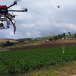
The toolbox, and indeed the drones were tested in the Andean agricultural landscapes of Ecuador, with each device fitted with an infrared camera and flown 60 meters above a potato field that is commonly attacked by a range of pests.
The drones were capable of taking accurate measurements of the spatial distribution of the surface temperatures of both the ground and the plants within it.
The operation was conducted with an accuracy of just 1-5 centimeters for both the visual and infrared images, so represents a high level of accuracy.
This level of detail is important, as until this point, they have struggled to accurately capture the micro-climatic conditions that occur within the global climate models. This micro understanding is crucial however, as it modifies the distribution of, and the response of, local species to the changing climate.
Having a better understanding of this, therefore, is crucial to our ability to properly plan and predict how climate change will impact on plants and animals.
The use of drones will allow this level of study to be done on a much larger scale and more cost-effectively than ever before, so could yield a substantial increase in our understanding of the climate and its impact on the world.