 The Internet of Things allows us to gain much richer insights into networks such as our railways and electricity grids. This insight is likely to be crucial as things such as renewable energy sources become even more mainstream. The ability to understand what electricity is flowing where and in what amounts will be crucially important for modern infrastructures.
A recent paper argues that to obtain this level of insight however, we need to get back to basics and understand that architecture in depth.
The OpenGridMap
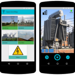
To help secure this understanding, a few hundred volunteers are helping via the OpenGridMap app. They browse cities looking for electrical infrastructure, whether it’s power lines, sub-stations or wind turbines.
Once found, the users share the location of the feature alongside a photo, with this data then sent to a server housed in Munich. The information is then analyzed and added to the OpenStreetMap system. Eventually, they hope to provide these kind of maps throughout the world.
“This is a prerequisite for the energy turnaround – not only here in Germany, but in all countries around the world. You can only plan the restructuring of the energy supply if you know exactly where powerlines are located and at which locations power from high-voltage lines is transformed and fed into the low-voltage networks,” the team say.
This then allows for better simulations of the impact renewable energy might have on the grid, or where bottlenecks might emerge. By overcoming a lack of open and transparent data, especially in emerging markets, creates a much richer picture for people to work from.
Recruiting the crowd
The project was helped significantly by a team recruited from the crowd. A group of volunteers had already been working on the open source OpenStreetMap for many years. Whilst this data did contain information on power grids, it wasn’t verified, so that was the next task for the team.
They did this by developing the OpenGridMap app and releasing it on Android. Through the app, they work with volunteers to map various electric facilities using their phones. The submissions are then verified before being uploaded to the open source map.
By analyzing the data, researchers have been able to calculate the location of power lines hidden under ground leading to residential properties. Eventually, the plan is for the data to be open to scientists and engineers around the world.
“There are many potential applications for the OpenGridMap,” the team explain. “You could investigate the feasibility of making a state like Bavaria energy autonomous.”