Credit: MIT CSAIL
Driverless technology has traditionally struggled in bad weather, due in part to the way road markings are obscured from the cameras used to orient and navigate the vehicles. New research from MIT’s CSAIL lab aims to overcome these challenges by adopting a different approach to the LIDAR-based approach most vehicles used today.
The researchers pondered whether looking beneath the road would help overcome the obstacles of a obscured road surface. The team developed a system based upon ‘ground-penetrating radar’ (GPR), which sends electromagnetic pulses underground to measure the specific combination of soil, rocks and so on in an area. This allows a kind of fingerprint to be created that they believe can help the car to orient itself.
“If you or I grabbed a shovel and dug it into the ground, all we’re going to see is a bunch of dirt,” they explain. “But LGPR can quantify the specific elements there and compare that to the map it’s already created, so that it knows exactly where it is, without needing cameras or lasers.”
Beneath the surface
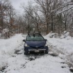
In testing, the team found that the average margin for error in snowy conditions was only about an inch more than in clear weather. The system was less successful in rainy conditions, where the margin for error expanded to 5.5 inches on average, with the team suggesting this is because rainwater soaked into the ground, thus leading to a bigger disparity between the original reading the the reading after rainfall.
Nonetheless, the team are confident in the robustness of their approach, and explain that during six months of testing, they weren’t required to unexpectedly regain control of the vehicle once.
“Our work demonstrates that this approach is actually a practical way to help self-driving cars navigate poor weather without actually having to be able to ‘see’ in the traditional sense using laser scanners or cameras,” they say.
Early days
It should be said, that the work to date has only been conducted at low speeds on a closed country road, but the team believe it can apply to built up areas and high-speed highways with equal effectiveness.
It’s the first time that researchers have utilized such a ground-penetrating radar, which had only previously been used in areas such as construction. The team don’t propose utilizing the technology on its own, but rather in conjunction with LIDAR. It can’t provide any detection above ground, but in bad weather it can compliment existing systems well.
The team also believe that using underground maps may provide greater longevity, as the features in an above-ground map are more prone to changes. What’s more, such underground maps are also believed to require around 20% less space than the 2D sensor maps used in many cars today.
It’s a long way from road-ready, but it’s an interesting example of the direction of travel for the industry. It will be interesting to monitor the developments in the technology in the coming years to see how it’s whipped into shape for the market. In the meantime, check out the video below to see the system in action.